 תכנון וניהול משק החשמל
A high-resolution, data-based, Israel-specific, VS30 map for hazard analysis
The resilience of a complicated civil infrastructure system, such as the electricity distribution system of a country, depends on its uninterrupted functioning, both under normal operational circumstances, as well as following extreme events, such as earthquakes.
Quantification of such resilience and reliability is performed via a thorough risk analysis, which is the product of the expected hazard, the vulnerability of the infrastructure system, and the expected consequences due to damage. Israel is located along an active plate boundary, with the Dead Sea Transform (DST) stretching along its eastern border. According to the historical, biblical, and archaeological records, devastating earthquakes are responsible for the repeated destruction of cultural centers in this region. Hence, evaluating the seismic hazard of civil infrastructures in modern Israel is essential for the resilience of the society as we know it
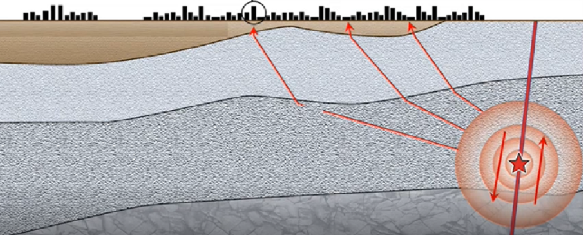
Seismic hazard analysis (SHA) requires :
- source characterization (typically location and geometry of faults, earthquake magnitude distribution, slip rate, etc).
- ground-motion characterization (typically represented by a ground motion model -GMM).
- Site-characterization.
For a single-site SHA, a detailed site-specific characterization is always the preferred option. However, for a system-wide SHA, such as that required to evaluate the resilience of an electrical production and distribution system – a regional estimation of site conditions is required. This is typically done in the form of a GIS-based map, representing a simple site-characterization proxy, such as site-class or VS30 – the time-averaged shear-wave velocity in the upper 30 meters, which has been the single most successful proxy for site-effect predictions since the early 1990’s.
this study aims to compile an extensive database of site-characterization, both at seismic station locations, as well as other locations throughout the country – to ensure a uniform sampling of different geological conditions. Each site will include measurements of geophysical, geological, and geotechnical properties, as well as analysis of ground-motion recordings where available. This database will then be used to develop local relationships tying site characteristics with a regional proxy, and eventually produce a continuous, data-based, GIS-compatible map for use in hazard and risk analysis.